I can spend longer looking for a new ride than getting ready for one. Bike Shows is a useful place to start: 212 routes give me plenty to browse. Yet I still reach the point where the familiar loops are too familiar and the promising new ones are nowhere near where I want to go.
There are hundreds more possibilities out there, probably thousands. They do not all come with a name and a GPX file. So I tried looking somewhere I would normally pass over: a collection of short driving itineraries.
This was an experiment. I took a day out from CarFest North, put its stops into a cycling planner and looked at what came back. I wanted to know whether a motoring guide could help me find a worthwhile ride. This is an account of that planning test; I have not ridden the resulting route.
Looking beyond the usual cycling routes
I am interested in the sort of driving itinerary that puts a market town and a long lunch ahead of clocking up distance. Its choice of places can be useful even when its choice of roads is not.
On quieter British country lanes, traffic can be light enough for sharing the road to be a reasonable part of a ride. Much of the cycling I want to do depends on that. A road does not become unsuitable because a motoring writer has mentioned it. Equally, a rural postcode does not make it quiet: I found no traffic counts for this test, so I cannot promise an empty lane.
My suspicion is that most driving itineraries become worse days out if you transfer them straight to a bicycle. Too much of the schedule assumes that the connecting journey is quick and costs the traveller very little effort. Keep every museum and every walk, then add the pedalling, and lunch starts to look like another deadline.
I would rather borrow two good stops and enjoy the road between them. Small digression: I distrust a leisure itinerary that gives lunch twenty minutes. That is barely enough time to choose something and take off a damp jacket.
I put the Bowland itinerary into a planner
For the test I chose the Clitheroe–Dunsop Bridge–Slaidburn day out. The driving version links three car parks over roughly 22 km. It leaves time for Clitheroe, a walk around Dunsop Bridge and an afternoon in Slaidburn. It is a one-way itinerary; reaching the start and getting home are extra.
I entered the same parking points into BRouter, selected the standard Trekking bike profile and kept its original result. I added no intermediate points to coax it into a prettier answer.
The result was 25.7 km with roughly 290 m of climbing. The web client displayed 287 m. That is about 17% farther than the rounded driving distance, before adding any return journey. The line went west out of Clitheroe, through Bashall Eaves and towards Whitewell, then on to Dunsop Bridge and through Newton to Slaidburn.
Already different.
- One-way distance
- 25.7 kmSame three parking points; no return leg
- Climbing
- About 290 m287 m displayed by BRouter-Web
- Surface tags
- 9.1 km asphalt16.6 km without a recorded surface
- Access to review
- 69 m of footwayShort pieces at Clitheroe and Dunsop Bridge
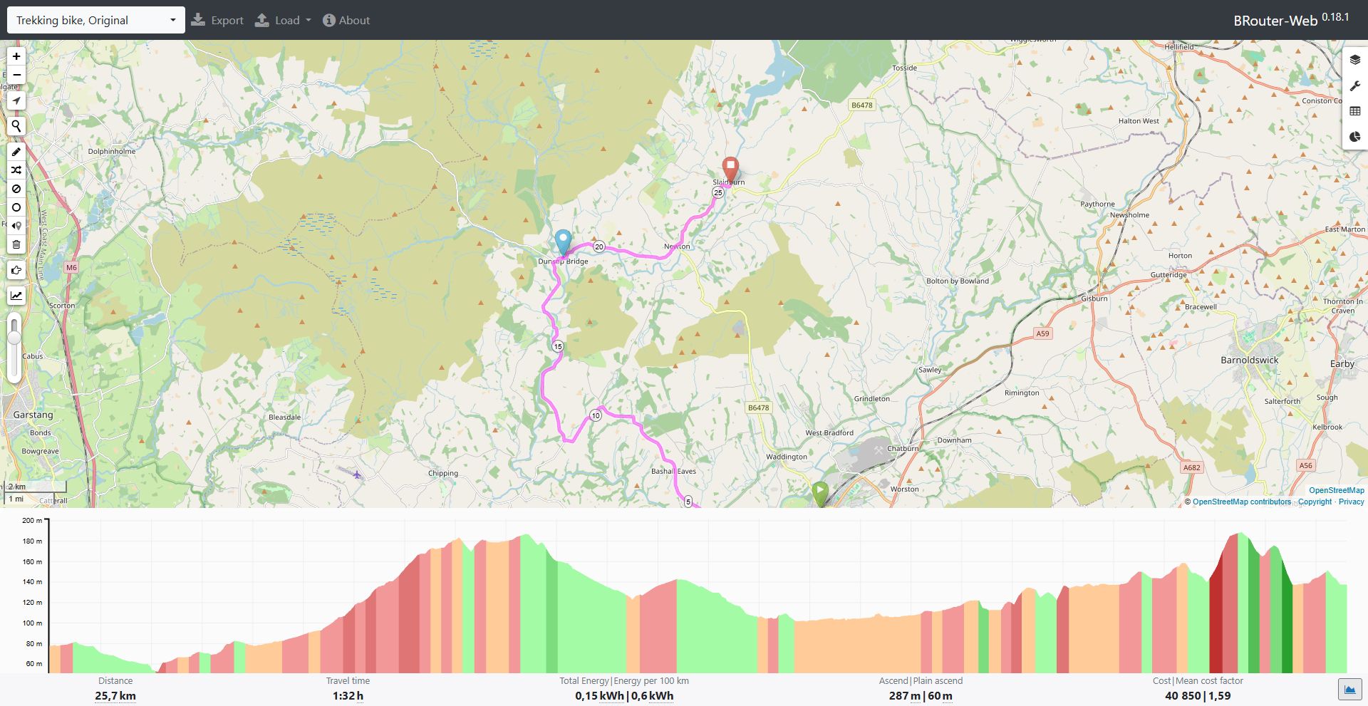
I saved the route data as well as looking at the map. It contained 9.1 km explicitly tagged as asphalt and 16.6 km with no surface recorded. Missing surface tags do not mean gravel. They do mean that I cannot honestly turn this result into a promise of continuous smooth tarmac.
Most of the distance followed ordinary roads. There were also 69 metres tagged as footway: two tiny pieces at the Clitheroe start and another on the approach to the Dunsop Bridge parking point. The returned tags did not explicitly confirm cycling permission on those pieces. I marked them for dismounting or rerouting, rather than treating the planner as permission to ride through.
The bits I would not gloss over
The first concern is the way out of Clitheroe. The result uses Bawdlands and Edisford Road, part of the B6243. Later it follows the B6478 from Newton towards Slaidburn. Altogether, 4.6 km falls into OpenStreetMap’s secondary-road category. That classification does not measure traffic, but these are road-sharing sections, not separated cycle paths.
The profile also gave me two places to pay attention to: the climb around kilometres 6–8 and the sharper rise around kilometres 23–24 after Newton. The latter appears in the web client’s 10–15% gradient band for a short stretch. That is a modelled indication, not a gradient I measured with a bike computer.
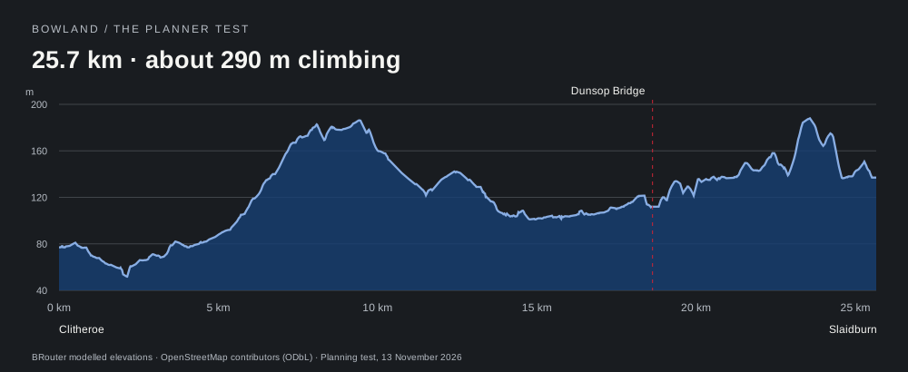
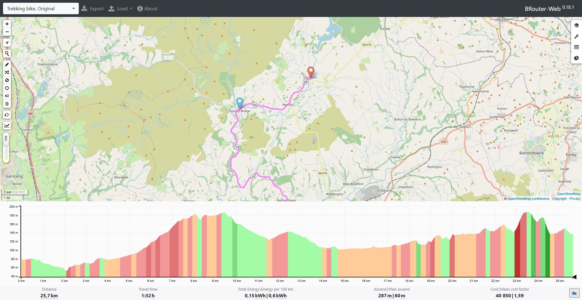
None of the total figures would put me off a day ride on their own. Add loaded panniers or a headwind, though, and the same distance becomes a different proposition. A wet, twisting descent needs time as well. I would not sell this first result as an easy family outing, and I would not hand someone its unedited track with a cheerful “off you go”.
That is where a cycle planner earns its place. The stops can stay while the connecting roads change. I can shift the start to avoid an awkward access path, inspect an alternative to a road section or drop a destination that makes the whole day cumbersome. Those would be further edits, not improvements I am claiming to have tested here.
I checked where the bike could go
The car parks were useful for locating the stops. They told me nothing about locking up a bicycle, so I checked the mapped cycle parking separately.
| Stop | Mapped locking point |
|---|---|
| Clitheroe | Stands about 130 m south of the Chester Avenue starting point; mapped capacity: six bicycles.53.873256, −2.394223 |
| Dunsop Bridge | Stands about 150 m north-west of the village car park; mapped capacity: six bicycles, public access, no charge.53.947093, −2.519720 |
| Slaidburn | Stands by the car park, about 40 m south-west of the finishing point; mapped capacity: twelve bicycles, public access, no charge.53.966315, −2.437988 |
These are OpenStreetMap records retrieved for the test, not racks I inspected in person. The Dunsop Bridge and Slaidburn records were last edited in 2019, so their presence and condition need checking on arrival. Northern also lists five cycle lockers on platform 1 at Clitheroe station; I did not establish their access arrangements, so I have not treated them as guaranteed visitor storage.
That changed how I read the original day out. A long riverside walk means leaving both bicycle and luggage somewhere suitable. A mapped stand can provide a locking point, but it does not solve the pannier problem. For this version I favour a shorter stop with the bike nearby over preserving the entire walking programme.
I also left café opening times out of the plan: I had no sufficiently reliable current hours to build the day around. Food in the bag is less faff than discovering that the lunch stop was the only place serving anything. The driving description remains useful for ideas, but its timetable needs rebuilding around riding, weather and daylight.
What I kept from the experiment
The useful discovery was the sequence of places. I started with a town, a valley stop and a village I wanted to connect, and ended with a measurable cycling proposal. That is progress beyond another evening of opening tabs.
I kept the destinations. I rejected the assumption that their driving connection was a ready-made ride, and the first cycling result still had issues of its own: incomplete surface information, short footways and road sections that deserved a closer look. The experiment gave me reasons to change the plan, rather than a vague assurance that it would probably be lovely.
For a weekend version, my next step is to arrange the return before adding any more attractions. The tested outward journey is 25.7 km with about 290 m of climbing. Riding back along the same line would make it roughly 51 km before detours, with climbing in both directions. That is the day I need to budget for—not the 22 km printed beside the driving itinerary.